Spatial Transformation
Subject Layer: Infrastructure
Analysis
We choose the road system as our research subject because it is the infrastructure people use most. We first came up with the theme with the pedestrian road, cycle lane, walking dog route, bus route, and car road, however only the car's road and bus route are more reasonable and predictable, so we focus on building a road system for cars and bus.
The road systems are organized into three layers: Main Road, Secondary Road, and Tertiary Road.
Depends on the traffic flow and connection, there are four main roads in this area, including one north-south road and three east-west roads. The north-south road is in the center of Vinkhuizen, and the other three east-west roads are situated in north, center, and south. Only the one in the center can go into the city road, the other two are connected to the high way.
Secondary roads are the road to connect neighborhoods to the main roads.
Tertiary roads are the final connection from the neighborhood to the house. It is also formulated the boundary of a little neighborhood block.
Finding
Vinkhuizen Road system
Road in three layer
Road in three layer+ bus stop
Transformation
We divide the road system into three layers: Main Road, Secondary Road, and Tertiary Road, and also mark the bus stop. We choose nail and thread as our main material. The red thread represents the main road, orange thread represents the secondary road, yellow thread represents the tertiary road, white thread represents the bus route and the wood clip represents the bus stop.
To separate the most important two main roads which are cross into the center, we mark the road thicker by winding nail with more threads, and each nail represents an intersection.

Almost all the important facilities are located on these four main roads, especially on the two roads that cross at the center. For the passenger, the main roads are the place to give them a first impression of Vinkhuizen.
Secondary road and third-class roads formulate the boundary of several small neighborhoods. It also represents the formal government's plan for this area.
Making a maquette is a way to visualize the research from the beginning, and also an initiative for the next step. However, I think there is no need to make this scale. A movable and small scale is easy to discuss together.
Conclusion
Sketch
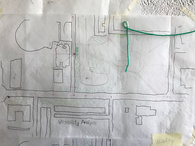
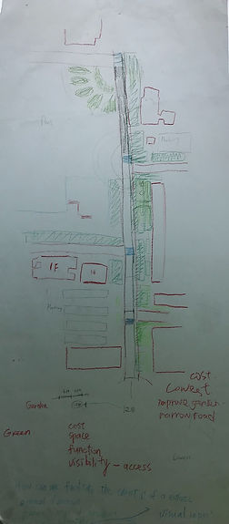
I did the visibility analysis and produce scenarios of different road types

High Investments

Medium Investments

Low Investments


Study Model and Plan


